Since their inception, maps have been embellished with illustrations. Through July 16, a selection of illustrated maps of New York spanning six centuries is on view at the New York Public Library. A preview of the exhibition—curated by Katharine Harmon and Ian Fowler—is presented below.
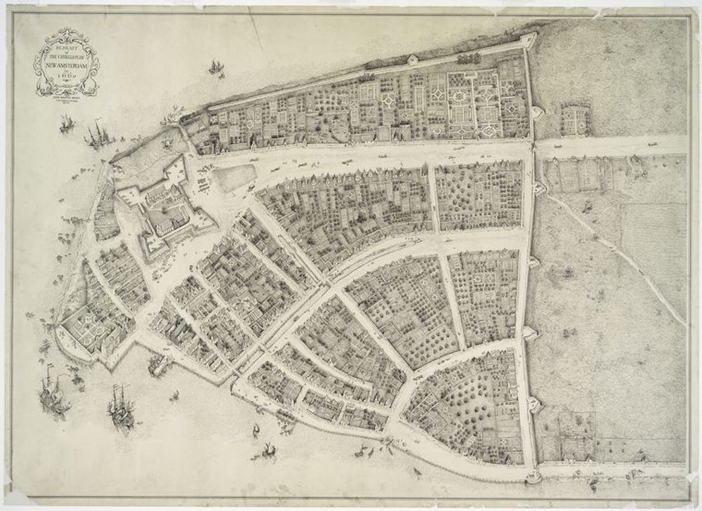
James Wolcott Adams, Redraft of the Castello Plan, 1916
The famed Castello Plan offers a rare view of new Amsterdam—located at the southern tip of what is now known as Manhattan—during the 40 year period of Dutch rule. Surveyor General Jacques Cortelyou made a map of the Dutch settlement in 1660 which was subsequently lost, but happily an unknown artist made a copy. This is the earliest map of the city existing today. It was sold to Cosmio de medici, Grand duke of Tuscany, around 1667, and “rediscovered” 233 years later at the Villa di Castello near Florence. American illustrator James Wolcott Adams redrafted the map in 1916; this hand-drawn copy of the original Castello Plan is housed in the Library’s Print Collection.
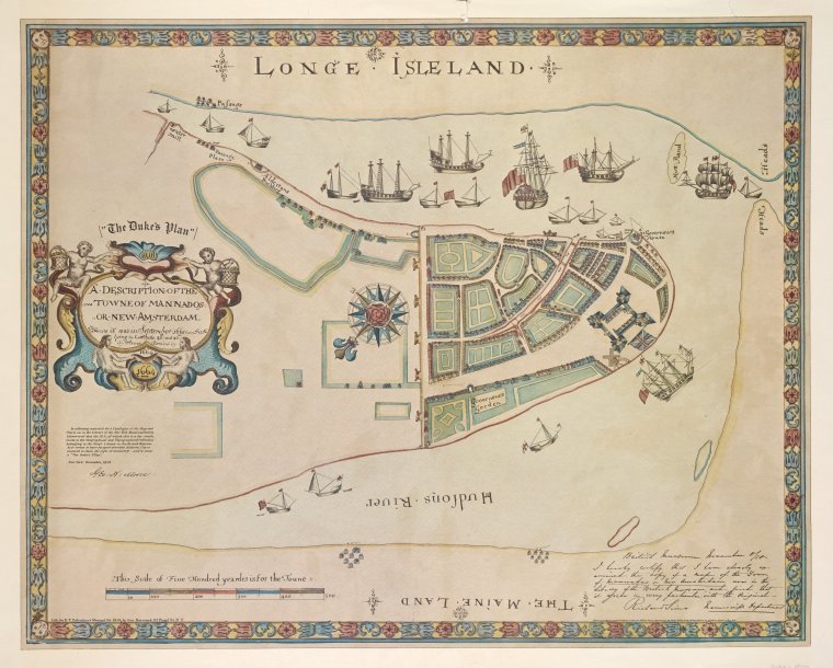
George Hayward, A description of the Towne of Mannados or New Amsterdam, 1664-1970
In 1664, the British captured New Amsterdam by order of James Duke of York. An unknown draftsman prepared for the Duke a revised version of Cortelyou’s plan, with the addition of triumphant British men-of-war. Gone are the smallholdings and kitchen gardens of the Costello Plan; still visible are the wall at the northern end of the settlement, now Wall street, the fort or battery, and the canal curving inward through the center of town.
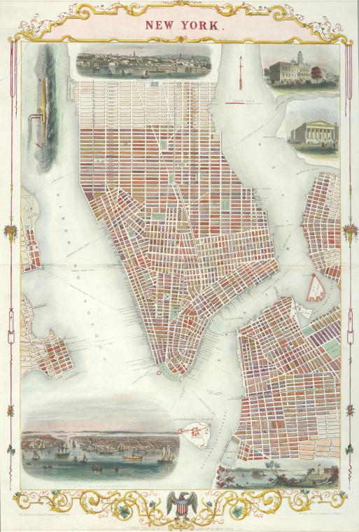
J. Rapkin, 1850
John Tallis, a renowned 19th century British map publisher produced the lavish Illustrated atlas of the world for the 1851 Great Exhibition in Lonon. The atlas is considered a decorative masterpiece. Tallis worked with the highly skilled engravers John Rapkin and Henry Winkles to create the atlas and other cartography that was both accurate and elegant. Their collaborations included the detailed city plans such as this view of lower Manhattan from 42nd street south to the Battery, with Governors island and parts of Jersey City, Hoboken, Williamsburg, and Brooklyn. Illustrated inset views depict a steamer, Brooklyn, City Hall, the Customs House, the Narrows from Fort Hamilton, and Manhattan as seen from Williamsburg.
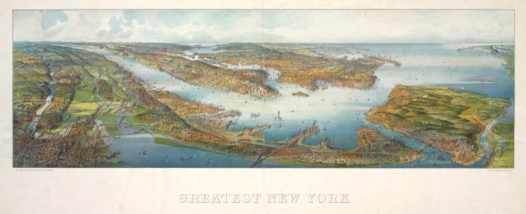
Henre Welge, Greatest New York, 1911
Henry Wellge was a German born map artist and publisher who produced more than 150 perspective renderings of small cities, mainly in the Midwest, ranging from Texarkana to billings, Selma to Duluth. He made this “greatest” map six years before his death in 1917. Bird’s eye views became a popular cartographic form in the 1840’s through the early 20th century. They offered oblique, aerial vistas as seen from imaginary perspectives – a tricky mapmaking skill, combining an architect’s draftsmanship with an artist’s aesthetic sensibilities. Currier and Ives and other publishers of the time used the newly developed technology of color lithography to produce affordable prints of thousands of locations in North America.
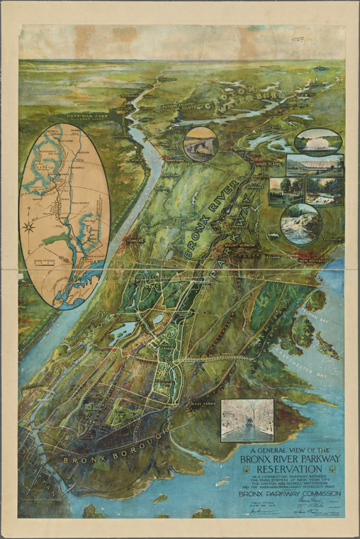
A general view of the Bronx River Parkway Reservation, 1915
The Bronx and points north are a pristine watery world in the map of the Bronx River Parkway, the first “open landscaped highway” in the nation, and the linear “reservation” surrounding it. Established in 1925, the reservation is Westchester’s oldest park; it extends 12 miles from New York City line north to the Kensico Dam Plaxa in Valhalla. It was originally designed in the late 19th century a a means of cleaning up the Bronx river, which had become an open sewer, dumping ground, and mosquito nursery. The parkway and its park, 18 years in the making, were an immediate success; by the summer of 1927 as many as 35,000 motorcars toured there on sunny weekends.
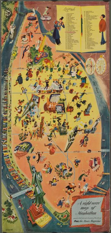
Paul Savitt, A sight-seers map of Manhattan, 1946
In 1946, according to this map, Harvey, Oklahoma! And Life with father were established hits on Brodway. A line of Rockettes towers over the ice skaters at Rock Center, ant at the Met, Brunnhilde holds forth at decibel levels loud enough to disturb the peace here at The New York Public Library. Up north, a Yankee pitcher faces off against a Giants batter. On the map’s inset, apparently a list of places to take a date, a map enthusiast helpfully highlighted a choice destination. Paul Savitt worked as a successful New York advertiser for 25 years before deciding, at the age of 46, to become a full-time fine artist. His childhood heroes were Paul Gauguin and Vincent van Gogh.
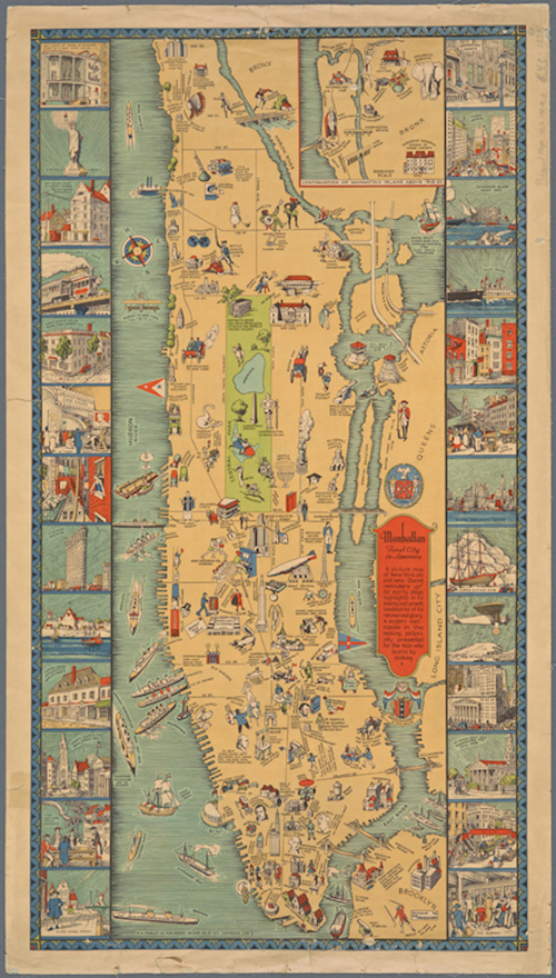
C.E. Millard, Manhattan, first city in America, 1933
Here is a map of a “modern metropolis in the making, pictorially presented for the man who learns by looking.” The man who created this map was an illustrator, decorator, theatrical designer, and painter; Millard is best known for his Art Deco poster designs. This view of New York is packed with historical trivia and whimsical figures, while scenic insets enhance the pictorial experience.
All images courtesy of the New York Public Library
from The Paris Review https://ift.tt/2JEfGIO
Comments
Post a Comment